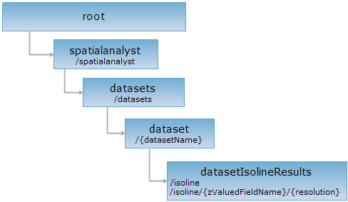
URI1:<dataset_uri>/isoline[.<format>]
URI2:<dataset_uri>/isoline/{zValuedFieldName}/{resolution}[.<format>]
Isolines can be extracted from a raster dataset or a point dataset. When isolines are extracted from a raster dataset, parameters filterQueryParameter, zValueFieldName, and resolution are not needed. URI2 can also be used to extract isolines on a point dataset. In this case, zValueFile and resolution passed in the URL.
Supported Methods:
Supported output formats: rjson, json, html, xml.

Implement the HTTP request on the following URI, where supermapiserver is the server name, with rjson being the output format.
http://supermapiserver:8090/iserver/services/spatialanalyst-sample/restjsr/spatialanalyst/datasets/SamplesP@Interpolation/isoline.rjson
Gets a form for the POST request.
Performing a POST request on the resource with related parameters creates the resource of a surface analysis result, i.e., performs a surface analysis for extracting isolines.
Parameters in the URI:
| Name | Type | Description |
| asynchronousReturn | boolean | Whether to employ asynchronous operation or not. If true, returns the URI of the new resource immediately after the client submits the request (returnContent setting doesn't work); if false, the server returns the description or the URI of the new resource URI according to the returnContent settings after analysis. The default is false. |
| returnContent | boolean | Returns the description or the URI of the new resource. If true, returns the description for the analysis result. If false, returns the URI. The default is false. |
URI1 is used to extract isolines from a raster dataset or a point dataset. The parameters in the request body are as follows:
Among the parameters, filterQueryParameter, zValueFieldName, and resolution are not needed if a raster dataset is used.
| Name | Type | Description |
| extractParameter | ExtractParameter | Parameters for extraction. |
| resultSetting | DataReturnOption | The extraction result setting. |
| filterQueryParameter | QueryParameter | The parameter for filtering the points to be interpolated. Only the points that satisfy the condition will participate in interpolation. |
| zValuedFieldName | String | The field name for the extracting operation. When extracting the isolines, the value in this field is used for interpolating the point data in the record set. The interpolation results a raster dataset (an intermediate result) based on which the isolines are then extracted. |
| resolution | double |
The resolution of the middle raster dataset, represent the actual distance represented by a cell, the unit is the same with resource dataset. The value range:
The recommended value: the one five hundredth of the extent of the source dataset. |
| clipRegion | Geometry | [Optional parameter] The clip region object. Use null to replace this parameter is do not need to perform clip operation. |
| expectedZValues | double[] | [Optional parameter] The expected analysis result Z value collection. |
URI2 is used to extract isoline from point dataset, the request body parameter is as the following: (zValueFieldName and resolution is passed in URL, the parameter description is as the table above.)
| Name | Type | Description |
| parameter | ExtractParameter | Parameters for extraction. |
|
resultSetting |
DataReturnOption | The extraction result setting. |
| filterQueryParameter | QueryParameter | The parameter for filtering the points to be interpolated. Only the points that satisfy the condition will participate in interpolation. |
| clipRegion | Geometry | [Optional parameter] The clip region object. Use null to replace this parameter is do not need to perform clip operation. |
| expectedZValues | double[] | [Optional parameter] The expected analysis result Z value collection. |
Normal response code(s): 201. The response parameters are as follows:
| Field | Type | Description |
|
succeed |
boolean | Whether the analysis is successful. |
| newResourceID | String | The ID for the analysis result resource. |
| postResultType | PostResultType |
The result type fo the POST request. |
| newResourceLocation | String | The URI of the newly created resource. |
Implement the POST request on http://localhost:8090/iserver/services/spatialanalyst-sample/restjsr/spatialanalyst/datasets/SamplesP@Interpolation/isoline.rjson and the parameters are as follows:
{
"zValueFieldName": "AVG_TMP",
"resolution": 3000,
"filterQueryParameter": {
"attributeFilter": "",
"ids": null
},
"extractParameter": {
"datumValue": 0,
"interval": 100,
"resampleTolerance": 0,
"smoothMethod": "BSPLINE",
"smoothness": 3
},
"resultSetting": {
"dataset": "pointIsoline",
"dataReturnMode": "DATASET_ONLY",
"expectCount": 100,
"deleteExistResultDataset": false
}
}
The returned resource description in rjson format is shown below:
{
"succeed": true,
"newResourceID": "1",
"postResultType": "CreateChild",
"newResourceLocation": "http://localhost:8090/iserver/services/spatialanalyst-sample/restjsr/spatialanalyst/datasets/SamplesP@Interpolation/isoline/1"
}
Performing a GET request on http://localhost:8090/iserver/services/spatialanalyst-sample/restjsr/spatialanalyst/datasets/SamplesP@Interpolation/isoline/1.rjson can retrieve detailed information about the analysis result. Please see datasetIsolineResult.
Asks for the response identical to the one that would correspond to a GET request, but without the response body. This is useful for retrieving meta-information written in response headers, without having to transport the entire content. The meta-information includes the media-type, content-encoding, transfer-encoding, content-length, etc.
HEAD request can be used to check if the datasetIsolineResults resource exists, or if the resource can be accessed by clients. It can also determine if the datasetIsolineResults resource supports an output format <format> if performed on a URI with .<format> included.